Every year, Bryn Mawr’s Geology Department takes a group field trip to a geologically-awesome location. Last year, we went to Costa Rica to study the volcanoes. The year before that, it was carbonates in the Bahamas. This year, we are taking an 8-day field trip to northwest Spain.
Why We’re Going
We spend the whole academic year studying the Appalachian Mountains. The Appalachians formed from a series of small continental collisions from ~500-400 million years ago – followed by one giant collision when Africa hit North America ~400 million years ago.
But what was happening on the other side of the ocean, as the Appalachians were forming? The rocks of northwest Spain record the flip side of the Appalachian Orogeny. These rocks started on Gondwana, an ancient supercontinent that mirrored North America for several hundred million years. The Spanish rocks were deformed in the same tectonic events as the Appalachians – but from slightly different angles.
Geologically speaking, the rocks of northwest Spain are the forgotten stepsisters of the Appalachian Mountains. By studying the mountains of northwest Spain, we see more completely what happens when oceans open and close over hundreds of millions of years.
The Geology of Northwest Spain: A Super-Quick Summary
The rocks of northwest Spain record the openings and closings of several oceans. They began as sediments, ~550 million years ago, on the northern edge of Gondwana, under the Rheic Ocean. These were the limestones and sedimentary rocks we see in the Cantabrian Mountains.
Around 390 million years ago, Laurentia (an ancient continent that would become North America) ran into Gondwana. This was the Variscan Orogeny, and it formed the mountain belts of Northwest Spain. The orogeny happened on the west coast of Spain, so the rocks are most deformed to the west. The Picos Mountains are the far-east extent of the Variscan Orogeny – they are only thrusted, not folded or metamorphosed.
In North America, we call the Variscan Orogeny the Appalachian Orogeny, and it formed the Appalachians. Same thing. The mountains of Northwest Spain are the Spanish equivalent of the Appalachians. Great. So by 370 million years ago, Gondwana and Laurentia were joined, and the NE U.S. and NW Spain were smashed together, right in the middle of a new supercontinent: Pangaea.
About 150 millions ago, Pangaea broke up, and NW Spain rifted off New England. The ocean rose and deposited carbonates on the northern edge of Spain. (These 90-million-year-old carbonates eventually became the caves near Atapuerca, where archaeologists would eventually find the oldest evidence of hominids in Europe – 1.2 million years old.)
Everything in Europe was quiet for a while after the break-up of Pangaea – until ~70 million years ago, when Africa came plowing north into it, causing the Alpine Orogeny. This major orogeny lifted mountains from the Cantabrians (Spain) to the Alps (Switzerland) to the Himalayas (India).
The Geology of Northwest Spain: A Little More Detail
Ok, let’s look at this in more detail.
The rocks of northwest Spain record the opening and closing of several oceans. Here’s how it all happened:
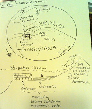 ~1 billion years ago: Basement rocks form. ~1 billion years ago: Basement rocks form.
We start with the basement rocks: the rocks on which all the rest of Spain’s rocks will be deposited. NW Spain’s basement started as sediments along the edge of the Amazonian Craton, a part of Gondwana that would eventually become South America. We know this from zircon dating. |
|
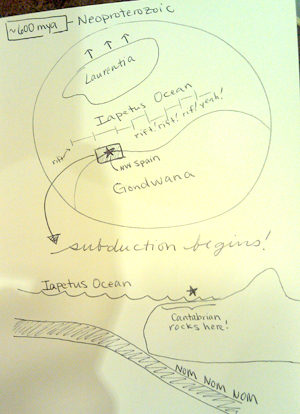 ~600 million years ago: Subduction begins. ~600 million years ago: Subduction begins.
Oceanic crust from the Iapetus Ocean began subducting below the north coast of Gondwana.
|
|
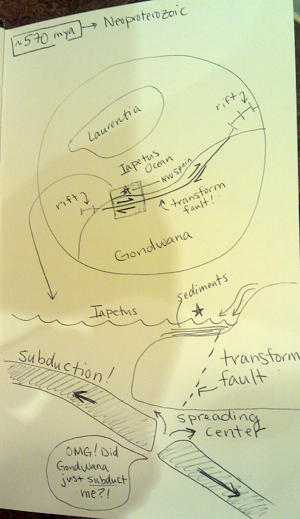 ~570 million years ago: Subduction zone eats a spreading center. ~570 million years ago: Subduction zone eats a spreading center.
This is always awkward. Subduction was so fast, it sucked a mid-ocean spreading center into the trench. This produced a transform fault, similar to the San Andreas of California. The transform fault began moving the Iberian basement rocks east along the margin of Gondwana – just like L.A. is being moved north toward San Francisco. Eventually, this transform fault will transfer our soon-to-be-Spanish rocks to the coast of West Africa, not South America. |
|
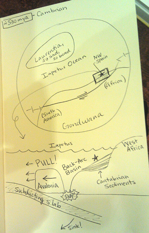 ~530 million years ago: Rheic Ocean opens. ~530 million years ago: Rheic Ocean opens.
Subduction began again along the north edge of Gondwana, seaward of the pelites and greywackes that were just deposited along the margin. The subducting slab produced a back-arc basin that became so deep the north edge of Gondwana rifted and a new ocean opened: the Rheic. The slice of Gondwana that rifted off became the microcontinent of Avalonia, which would eventually hit Laurentia and contribute to raising the Appalachian Mountains.
As the Rheic opened wider, the north edge of Gondwana again became a passive margin. Sandstones, mudstones, and limestones were deposited along this margin.
|
|
 ~530-440 million years ago: Rheic Ocean widens. ~530-440 million years ago: Rheic Ocean widens.
When the Rheic Ocean opened, it opened in the middle of the Gondwana passive margin deposits. The passive margin deposits on the seaward side of the rift became Avalonia and drifted away to the north. The deposits landward of the rift stayed attached to Gondwana, and would become the Cantabrian rocks of Northwest Spain. Meanwhile, the north edge of Gondwana again became a passive margin, and 100 million more years of sediments were deposited on top. |
|
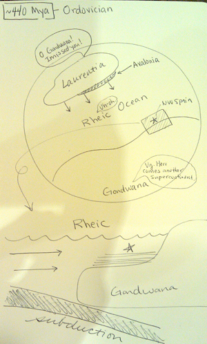 ~440 million years ago: Subduction starts again. ~440 million years ago: Subduction starts again.
When subduction began off the coast of Gondwana again, it began pulling the Rheic Ocean closed. Laurentia was on the other side of the Rheic, and it was pulled closer and closer. |
|
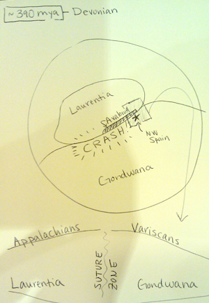 ~390 million years ago: Variscan Orogeny begins. ~390 million years ago: Variscan Orogeny begins.
When the Rheic was finally pulled completely closed, Laurentia hit Gondwana, causing the Variscan Orogeny. In North America, this is called the last stage of the Appalachian Orogeny.
This first stage of the Variscan caused the first set of thrust faults in the Picos Mountains, which we visit on Day 2 of the trip.
~390-340 million years ago: Variscan continues, Pangaea forms.
The Variscan/Appalachian Orogeny lasted several million years. By the end, Laurentia and Gondwana had merged into the supercontinent Pangaea. Late in the Variscan, the Iberian Massif was rotated, and new thrust faults formed, deforming the Ponga Nappe Province.
~320 million years ago: Extension in the Iberian. After the initial collision, there was a period of relaxation and extension. The Variscan granites that underlie most of the western half of the Iberian Peninsula were emplaced due to delamination of lithospheric mantle
~150 million years ago: Pangaea starts to break up. The Atlantic Ocean begins to open, splitting New England apart from the Iberian Peninsula.
~100 million years ago: Sea transgression. This intercontinental sea deposited the cherts and limestones that would eventually become the caves at Atapuerca. These are the caves in which the oldest evidence of hominids in Europe would eventually be found.
~90 million years ago: The Bay of Biscay opens, sea transgression. Africa rifted away from Gondwana, and the Iberian Peninsula rotated to make room, causing seafloor spreading in the Bay of Biscay. This resulted in a transgressing sea, which deposited the cherts and limestones that would eventually become the caves at Atapuerca. These are the caves in which the oldest evidence of hominids in Europe would eventually be found.
~70-40 million years ago: Alpine Orogeny. Africa and India plowed north into Eurasia, raising a series of mountains from the mountains of Northwest Spain to the Alps to the Himalayas. |
“ |


 ~600 million years ago: Subduction begins.


 ~390 million years ago: Variscan Orogeny begins.