Spain Trip ’12: Putting it All Together

Over the course of 6 days, Bryn Mawr’s Geology Department traversed a set of rocks that record a complex mountain-building event across northwestern Spain.

Suki Lopez (BMC '15) shows off a Proterozoic granite that was deformed in the collision between modern North America and modern Africa. This granite is the oldest known rock of the Iberian Peninsula.

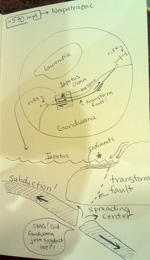
The Neoproterozoic: Subduction and a Passive Margin

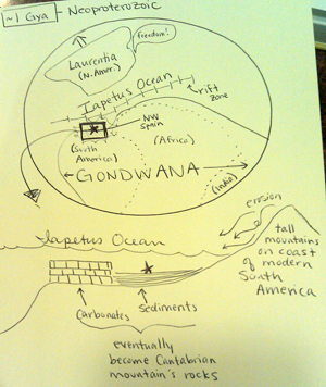
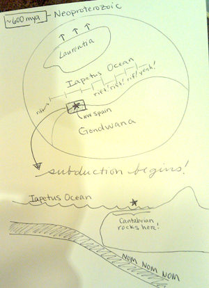
The story of northwest Spain begins ~600 million years ago.  Laurentia (modern North America) and Gondwana (modern South America, Africa, India, Antarctica, and others) had recently rifted apart as the supercontinent Rodinia broke apart.  The Iapetus Oceanseparated the two continents.

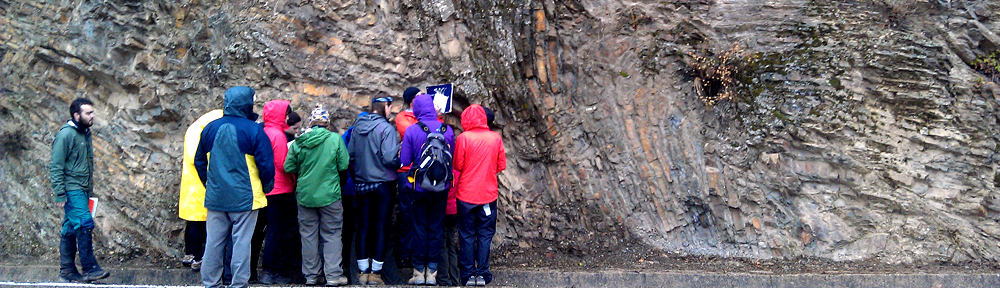
On the northern coast of Gondwana, an ocean plate began subducting, producing melts that rose into the overlying crust and became granites.  We observed these granites at the roadside outcrop near Pola de Allande.  There, the granite had been foliated and deformed by later tectonism, but it still represents the oldest known rocks of Iberia.  The rocks into which these granites intruded have never been found.

As subduction continued during the Neoproterozic, erosion of Gondwana was depositing a thick sedimentary sequence onto the continental margin.  Clay-rich shales, sandstones, and limestones deposited onto the continental margin, interbedded with the occasional calc-alkaline volcanic ash from nearby subduction-related volcanism.  We observed these sedimentary rocks at the roadcut showing the Precambrian-Cambrian unconformity.

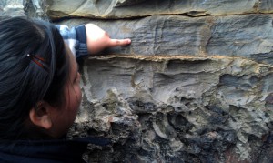
Danyelle Phillips (BMC '14), Storrs Kegel (HC '13) put their hands on the angular unconformity between the Precambrian and Cambrian

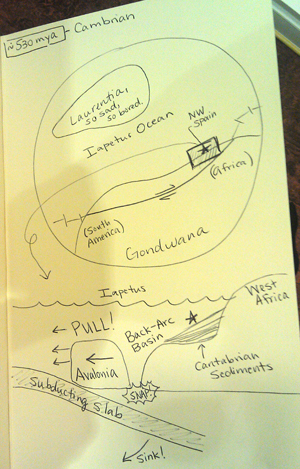
The Cambrian: A Passive Margin

During the Cambrian, passive margin sedimentation continued along the northern coast of Gondwana.  We saw evidence of this sedimentation at three places along our cross-section:

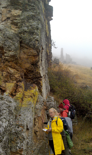
  • The Luna Dam, just outside Barrios de Luna, in the Foreland Fold and Thrust Belt.  There, we saw red nodular limestones, shales, and sandstones with cross-bedding from the Middle Cambrian.  These layers were tilted to their near-vertical position by the later Variscan Orogeny.
  • The Precambrian-Cambrian unconformity roadcut.  These layers were later folded and tilted to their near-vertical position by the Variscan Orogeny.
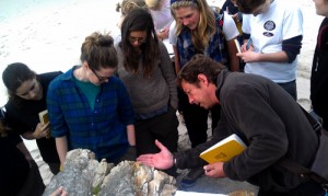
  • Gabi Gutierrez-Alonso shows the students cleavage planes in the upside-down Cambrian sandstone overturned by a recumbent fold

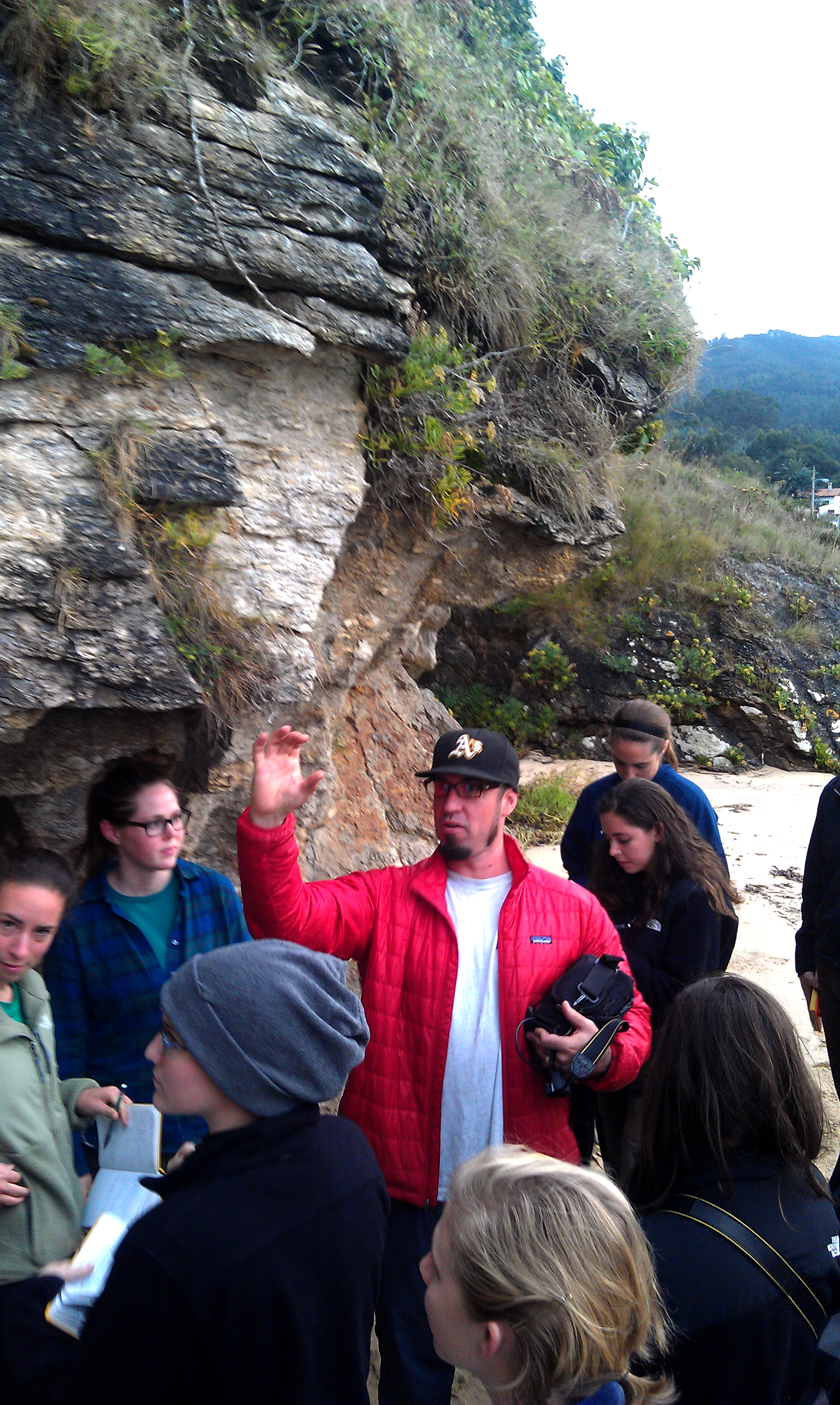
    The upside-down quartz sandstone at Binquereia Beach, in the Fold and Nappe Province, further into the hinterland of the orogeny.  This sandstone had upside-down cross-bedding, indicating that it was on the lower limb of a recumbent fold.   This giant fold was part of the Mondono Thrust, which formed later in the Variscan.

Taken together, we see that the Cambrian was a time of various marine environments off the coast of Gondwana: limestones, shales, and sandstones deposited on the passive margin of the Iapetus Ocean.

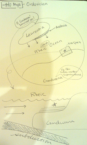
The Ordovician: Rifting of Avalonia

Fern Beetle-Moorcroft (HC '14) and Suki Lopez (BMC '15) point to some feldspar lenses in Ordovician gneisses

Toward the end of the Cambrian, subduction began on the opposite side of the Iapetus Ocean, on the east coast of Laurentia.  The subduction was so intense that it pulled the whole Iapetus Ocean toward Laurentia, including Gondwana.  The northern edge of Gondwana tore off, forming the long, narrow terrane of Avalonia (~480 Ma).  Between Avalonia and Gondwana, a mid-ocean spreading center opened up, pushing Avalonia away and spreading open a new ocean: the Rheic Ocean.

Erin Kennedy (BMC '13) with some deformed Ordovician phyllites

The rifting event caused heating and melting in the Gondwana foreland.  Granitic melts intruded into Gondwana.  During the Variscan, these granites would be metamorphosed into the granitic gneisses we saw at Xilloy Beach, where the giant white alkali feldspar crystals formed lenses in the layered gneiss.  The original granites were emplaced around 490 million years ago, near the Cambro-Ordovician boundary.

Meanwhile, the continental margin of Gondwana was still passive, and still collecting sediments – this time in the Rheic Ocean, not the Iapetus.  We saw many Ordovician-age sedimentary rocks during this trip:

  • The Armorican Quartzite that we observed at the Luna Damn near Barrios de Luna was deposited during this time, in the shallow sea between Avalonia and Gondwana.
  • Emily Garcia (BMC '15) points to some crenulation cleavage in Ordovician-age phyllites

    The beautifully-deformed phyllites at Porcia Beach were originally deposited as mudstones and shales in the Rheic during this time.  These rocks were further toward the hinterland of the Variscan, and so underwent more intense metamorphism and folding as they were thrust eastward by the Mondonco Thrust Fault.

  • The granulites we saw on the beach near Carino, in the Cabo de Ortegal Complex at the end of the trip, also formed during this time, but not as part of Gondwana.  These sediments were part of the Avalonia passive margin, and went riding off with Avalonia toward Laurentia.  They would eventually be reunited with Gondwana during the Variscan.

Suki Lopez (BMC '15) points out the kaolinite ash layer in the Armorican Quartzite

The rifting of Avalonia also caused volcanism along the north coast of Gondwana.  At ~456 million years ago, a supervolcano erupted off the coast of Gondwana, induced by the rifting event.  The massive ashfall covered all of the coast of Gondwana, and can now be found as a thick kaolinite (clay) layer throughout Ordovician-age sediments in Europe.  We observed this kaolinite layer in the Cambro-Ordovician sequence at the Luna Damn near Barrios de Luna.  There, the kaolinite layer had been compacted by the quartzite that sandwiched it, but was still more than a foot thick.

The Silurian: Death of the Iapetus

By ~420 million years ago, 60 million years after it had split off from Gondwana, Avalonia docked at Laurentia, another in a set of minor orogenies that collectively would make the Appalachian Orogeny.  This docking officially closed the Iapetus Ocean, and now only the Rheic remained between Gondwana and Laurentia.

At about the same time, subduction began off the coast of Gondwana, pulling the Rheic Ocean closed and Laurentia closer in.

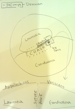
The Devonian: Rapid Closing of the Rheic

Storrs Kegel (HC '13) and Sarah Glass (HC '14) show off a chevron fold in Devonian-age shales within the Alba Syncline

Early in the Devonian, sedimentation continued along the Gondwana margin, even as the Rheic was closing.  We saw evidence of this in several outcrops:

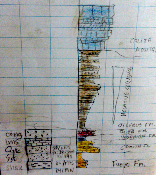
  • In the Corresillas Conglomerate, we saw Devonian-age sandstones, rich with crinoids fossils.  These must have formed early in the Devonian, along the continental margin.
  • In the Alba Syncline sequence, we saw a series of deep marine shales and shallow marine quartzites that had been deposited on the Gondwana continental margin, and were later folded and metamorphosed during the Variscan.

Around 390 million years ago, Laurentia subducted the mid-ocean spreading center in the Rheic.  This rapidly sped up the closing of the ocean, and Gondwana and Laurentia drifted toward each other faster.

Danyelle Phillips (BMC '14) examines black shales at the Devonian-Carboniferous boundary in the Alba Syncline

The Early Carboniferous: The Variscan Orogeny

In the early Carboniferous, sedimentation continued as usual on the margin of Gondwana, as Laurentia continued to pull the Rheic closed.  We saw evidence of this in the Alba Syncline sedimentary sequence, where the Devonian-Carboniferous boundary shows up as a fissile layer of black slate.  In that sequence, we saw red nodular limestone laid down at the beginning of the Carboniferous, followed by more shale.

Around 325 million years ago, Gondwana and Laurentia began colliding.  The western portions of Gondwana were affected first, as the collision forced giant fold and thrust belts up eastward onto Gondwana.  You can watch a video of this process on Gabi’s YouTube Channel.

We saw abundant evidence of this in our trip:

  • In the hinterland, we saw evidence of huge thrust belts that folded, faulted, and moved continental margin sediments hundreds of kilometers inland.  The complex folds we observed in the gray phyllites at Porcia Beach formed during this time.

    Z folds in the Alba Syncline, produced by Erin Kennedy (BMC '13), Danyelle Phillips (BMC '14), Sarah Glass (HC '14), and Gabi Gutierrez-Alonso

  • Further toward the collision zone, we saw the limbs of a giant recumbent fold, propelled by the Mondonoco Thrust Sheet.  This sheet alone shortened material by 180 km along the continental margin.
  • Further from the collision zone, the Alba Formation was folded into the Alba Syncline.
  • The Precambrian-Cambrian boundary we observed was folded during this time.

Kelsey Meisenhelder (HC '14) holds a piece of harzburgite, a piece of the Earth's mantle

In addition to folding and thrusting the Gondwanan rocks, the Variscan Orogeny produced a suite of granitic rocks and smashed an ophiolite sequence up into the suture between Gondwana and Laurentia.  We saw evidence of this in several places near the suture:

  • The tectonic melange near Espasante
  • A piece of Avalonia, left over from the collision, in the granulites near Carino
  • The eclogites of Cabo de Ortega
  • Harzburgites representing sub-oceanic mantle
  • Deformed sheeted dikes

The Late Carboniferous: Oroclinal Bending

By the end of the Carboniferous, the mountains produced by the collision were shedding sediments.  We saw evidence for this in the Corresillas Conglomerate, which formed during this time of cobbles from nearby mountains thrust up during the first phase of the Variscan.

Fern Beetle-Moorcroft (HC '14) shows a conglomerate clast that has been fractured during the oroclinal bending event.

The collision had more subtle effects than just pushing up dramatic thrust sheets.  As the continental margin shortened and more and more Gondwanan rock piled up, the pile began to weigh down the crust, just like a bowling ball placed in a blanket will dimple the blanket downward.  The result was a deep basin inland of the collision zone – the foreland basin.

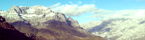
During this time, marine water filled the foreland basin along Gondwana.  There, a thick sequence of carbonates precipitated, forming the rocks that would eventually become the Picos de Europa Mountains. 

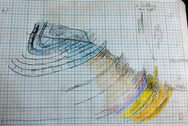
Late in the Variscan Orogeny, the rocks of Northwest Spain experienced an oroclinal bending event: the area was rotated 90 degrees and compressed again, forming thrust sheets at right angles to the original Variscan thrust sheets.  The overprinting of these two sets of thrusts produced the crazy folds of the Ponga Province, and the second set of thrusts pushed the limestones of the Picos de Europa Mountains up into the relief we saw.

Ultimately, the oroclinal bending event produced the Iberian-Armorican Arc, a continent-scale arc of mountains.  You can watch a video of the oroclinal bending process at Gabi’s YouTube Channel.

Professor Arlo Weil diagrams the limestone thrusts in the Picos de Europa Mountains

The oroclinal bending event also produced a series of granites.  As the bending proceeded, the inner part of the arc thickened past the point of stability, and the underlying lithosphere delaminated.  Hot asthenosphere rushed up into the lower crust, producing melts that would become the post-orogenic granites of Northwest Spain.   You can watch a video of this process on Gabi’s YouTube Channel.

The Carboniferous to Jurassic: Pangaea

The Variscan was one of several orogenies that assembled the supercontinent Pangaea.  For ~170 million years, the mountains of Northwest Spain sat in the middle of the supercontinent.  Then, about 200 million years ago, the Atlantic Ocean began opening, and separated Northwest Spain from North America again.

The Cretaceous: An Inland Seaway

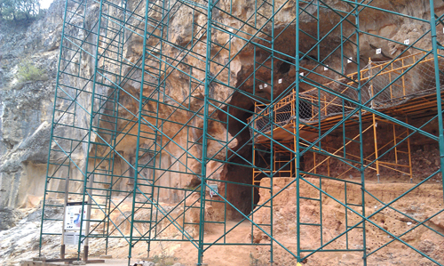
At the limestones caves of Atapuerca, where were found the oldest remains of hominids in Europe

After the Atlantic had opened, marine waters invaded the coast of Northwest Spain, depositing the limestones that we observed near Atapuerca.  Eventually, these limestones formed the caves in which were found the earliest evidence of hominids in Europe.  We saw evidence for these processes at the caves near Atapuerca, including Sima de Elefante, site of the oldest European hominid. 

Fall 2012: An Amazing Trip!

Gabriel Gutiérrez-Alonso and Arlo Weil, thank you for an amazing field trip!

Gabriel Gutiérrez-Alonso and Arlo Weil tell us how the Picos Mountains got there. 'Cause they're just that awesome.

Spain Trip, Day #6: Into the Continental Collision Zone

On Day 6 (Friday, October 19), we moved from the hinterland of the Variscan Orogeny into the orogeny itself.  Throughout the day, we saw evidence of the 390-370 million-year-old collision between Gondwana and Laurentia, from tectonic mélange to a piece of ocean crust caught between the two colliding land masses.  Together, these stops make up an ophiolite: a cross-section of ocean crust that was scraped off onto the continent during collision.

The Stuff That Got Scraped Off the Top: A Tectonic Melange

Ilena Pagen (BMC '15) points to a migmatite: a partially-melted rock.

We started the day at the beach near the town of Espasante, examining a tectonic mélange: a mishmash of many types of rocks.  Melanges form on the edges of subduction zones, when the subducting plate scrapes off its top rocks onto the overriding continent.

At this mélange, we saw many rock types, all metamorphosed and smashed together:

  • An amphibolite that had once been an eclogite.  Eclogites are the highest temperature and highest pressure rocks on Earth – they only form in subducting ocean crust.  This ocean slab had metamorphosed to an eclogite, then been exhumed and thrust up into the subduction zone, where it underwent retrograde metamorphism.  Its pyroxenes turned into amphiboles and it became a garnet-bearing amphibolites.
  • A serpentinite – a serpentine- and talc-bearing rock that forms from metamorphism of olivine-rich rocks from Earth’s mantle.
  • Migmatites – rocks that were heated so hot they began to melt.  This migmatite appeared to be granitic, indicating initial melting of sedimentary rocks.
  • Greenschists from mafic volcanic
  • White marble entrained with serpentinite

These rocks together are indicative of an ocean environment: mantle rocks, ocean crust, sedimentary materials, mafic volcanic, and limestone were all mashed together and metamorphosed, before being scraped up off onto the edge of Gondwana.

The migmatites at this site had been dated at 490 million years, meaning this mélange likely formed at a subduction zone on Laurentia.  It was then mashed up onto the edge of Laurentia by the Avalonia collision.

A Piece of the Overriding Plate: Avalonia

At our second stop, we visited a beach near the village of Carino.  There, we found granulite facies rocks: metamorphic rocks that had been heated to high temperatures but low pressures.

This granulite was formed from Cambro-Ordivician sediments that formed on the edge of Gondwana.  These sediments then must have rifted off Gondwana with Avalonia, ~480 million years ago, travelled across the Iapetus Ocean, collided with Laurentia ~420 million years ago, and stayed with Iberia when Pangaea finally rifted apart.  They have crossed the ocean that is now the Atlantic at least twice.

The Subducting Plate: Eclogites

Chloe Weeks (BMC '13) shows off a piece of eclogite, the highest-temperature, highest-pressure type of metamorphic rock

At Cabo de Ortega, we visited the largest outcrop of eclogites in the world.  Eclogites are extremely high-temperature, high-pressure rocks made from the metamorphism of basaltic rocks.  They only form in subduction zones, when oceanic plates dive below continental crust and experience extreme pressures and temperatures.

The eclogites at Cabo de Ortega contain the classic omphacite-garnet mineral assemblage that typify the rock.

These eclogites were likely still part of Avalonia.  This was the piece that was subducted under Laurentia during Avalonia’s docking around 420 million years ago.

The Mantle

Atop a mountain now lined with giant wind turbines, we found an outcrop of the black rock harzburgite: an olivine- and pyroxene-rich rock that forms when the mantle partially melts below oceanic crust.  This mantle rock must have been lifted up onto the edge of Laurentia along with the eclogites from Cabo de Ortega during the docking of Avalonia.

Kelsey Meisenhelder (HC '14) holds a piece of harzburgite, a piece of the Earth's mantle

The Ocean Crust: Deformed Gabbros

We saw the mantle below the ocean crust and the sediments deposited on top of the ocean crust.  The final piece of the ophiolite is the ocean crust itself.  This deformed gabbro is typical of normal mid-ocean ridge basalts (N-MORBs), and likely formed just as the Rheic was opening to rift Avalonia off of Gondwana, ~490 million years ago.  Later, most of that ocean slab would be subducted below Gondwana in the Variscan Orogeny – this particular outcrop was caught between the continents and lifted up on top of Gondwana instead.

The Ophiolite

Taken together, today’s outcrops represent an ophiolite: a cross-section through ocean crust that is lifted up onto a continent during an orogeny.  The top of the sequence is the mélange: the material scraped off the top of the subducting slab.  Then comes the subducting slab itself, the ocean crust before subduction, and the mantle.  Here, the overriding continental crust is also preserved in the form of granulites.


Spain Trip, Day #5: Into the Hinterland

On Day 5 (Thursday, 18 October), we left the foreland area of the Variscan Orogeny and drove into the hinterland, closer to the suture zone where Gondwana and Laurentia collided.

Deformed Proterozoic Granitic Rocks

We started the day by examining some foliated granites near the village of Pola de Allande.  These granites were dated at 600 million years, making them the oldest known Iberian rocks.  They are calc-alkaline granites, indicating they formed in a subduction environment.  An ocean slab must have been subducting off the north coast of Gondwana, under the Iapetus Ocean.  The granites were later foliated during the Variscan orogeny.

Suki Lopez (BMC '15) shows off a Proterozoic granite that was deformed in the collision between modern North America and modern Africa

Following a Giant Thrust Sheet

We stopped at two outcrops today that had been affected by the giant Mondonedo Thrust Fault:  a 60-km-long thrust fault that happened during the Variscan Orogeny.

At the first stop, at Porcia Beach, we saw a stack of Ordovician-age phyllites, rich in graphite and mica and showing great examples of crenulation cleavage, isoclinals folding, and ptigmatic folding of quartz-chlorite veins.  This sequence was deposited on the passive margin of Gondwana, after Avalonia rifted off but before Laurentia and Gondwana collided.  It was then folded and faulted during the Variscan Orogeny, along the Mondonedo Thrust.

Emily Garcia (BMC '15) points to some crenulation cleavage.

At the second stop, at Binquerencia Beach, we observed Cambrian sandstone with cross-bedding indicating that stratigraphic “up” now pointed down into the ground – the beds had been overturned.  This makes this sequence the bottom lib of a giant recumbent fold: a fold that has been pushed over onto its side.

Gabi Gutierrez-Alonso shows the students cleavage planes

Deformed Ordovician Granitic Rocks

Professor Arlo Weil discusses gneiss deformation

We began the day looking at deformed Proterozoic granites.  We ended by looking at deformed and metamorphosed Ordovician-age granitic gneisses.  The gneisses exposed along Xilloy Beach contain large alkali feldspar grains (“eyes”) that have been deformed into lens shapes.  The original granite protolith formed about 490 million years ago, during the Ordovician, and was later deformed during the Variscan.


Fern Beetle-Moorcroft (HC '14) and Suki Lopez (BMC '15) point to some feldspar lenses in Ordovician gneisses


Spain Trip, Day #4: Deeper in Time

The Bryn Mawr Geology Department with Precambrian folded rocks of Gondwana

On Day 4 (Wednesday, 17 October), we examined older rocks of the Iberian Massif: a thick Paleozoic sequence that had been deposited on the passive margin of Gondwana, and the angular unconformity separating Proterzoic from Cambrian rocks.

Paleozoic Rocks Near the Luna Dam

We began the day by driving from Barrios de Luna, over the Luna Dam, to a thick sequence of Paleozoic sedimentary rocks.

At the top of the sequence outcropped the Armorican Quartzite– a highly resistant quartzite that can be found all across Europe.  The Armorican likely formed on the continental margin of Gondwana during the Lower Ordovician, just after the rifting of Avalonia and opening of the Rheic.

Suki Lopez (BMC '15) points out the kaolinite ash layer in the Armorican Quartzite

Embedded in the Armorican, we found a 1-foot-thick layer of kaolinite, an aluminum-rich clay that forms from weathering of feldspars.  The kaolinite has been dated to 456 million years and is found across Europe (the old northern edges of Gondwana).  It is likely that this continent-wide kaolinite layer was originally a continent-wide layer of volcanic ash, rich in feldspars.  Such an ash layer could result from a super-volcano eruption, hundreds of times more powerful than the Mount St. Helen’s eruption.  Such a volcano might have formed on the margin of Gondwana, as the Avalonia rifting event caused crustal extension and volcanism.

Below the Quartzite and ash layer, we found a Middle Cambrian sedimentary sequence, including trilobite-bearing shales, sandstones with cross-bedding, and a red nodular limestone that forms the main detachment layer for the thrusts we saw in the Picos Mountains on Day 2.

The Precambrian-Cambrian Unconformity

Chloe Weeks (BMC '13), Danyelle Phillips (BMC '14), Rachel Davis (BMC '13), and Storrs Kegel (HC '13) put their hands on the angular unconformity between the Precambrian and Cambrian

After visiting the Luna Dam outcrop, we stopped at a road cut that exposed the angular unconformity between the Precambrian and Cambrian.   The Precambrian sandstones and shales had been tightly folded and faulted, then uplifted and exposed to erosion.  The Cambrian sediments had then been deposited on top of them, making a spectacular angular unconformity at the base of the Paleozoic.

Spain Trip, Day #3: Evidence of Oroclinal Bending in Variscan Conglomerates and the Alba Syncline

On Day 3 (Tuesday, 16 October), we visited two sites: the Corresillas Conglomerate and the Alba Syncline.

To put this in context: yesterday (Day 2), we visited the Picos de Europa Mountains: thick sheets of limestone that formed late in the Variscan Orogeny.  As Laurentia and Gondwana collided in the Carboniferous, they produced deep foreland basins surrounding the main collision zone.  Those foreland basins filled with seawater and precipitated limestones.  Later, the whole Iberian area was rotated 90-degrees, and compression came from what is now N-S.  This was an event called oroclinal bending, and it thrust the foreland limestones up onto the Gondwana continent, forming the Picos de Europa Mountains.

Today, we visited two sites that formed earlier during the Variscan and were later modified by the oroclinal bending event.  First, we visited the Corresillas Conglomerate, which formed from debris shed from Variscan mountains.  The Corresillas was later fractured and tilted by the oroclinal bending event.  Then, we took a long hike through the Alba Syncline, a sequence of Paleozoic rocks that was folded during the Variscan Orogeny, and later tilted by the oroclinal bending event.

Taken together, we are continuing to see evidence of how the Variscan Orogeny and later oroclinal bending affected the rocks of Gondwana’s foreland basin.

The Corresillas Conglomerate

Professor Don Barber discusses conglomerate processes with Jenna Meyers (BMC '14) and Chloe Weeks (BMC '13)

The Corresillas Conglomerate formed during the upper Stephanian (a time period of the Carboniferous), ~305 million years ago.  The Variscan Orogeny had already been going on for ~80 million years, and had produced high mountains to the west.  The mountains shed debris into surrounding flood plains (often just basins between thrust sheets).  There, powerful rivers moved cobbles and boulders long distances, forming the Corresillas Conglomerate.

We know this conglomerate formed close to its source materials.  It is poorly sorted (grain sizes range from tens of centimeters to submillimeter), and many of the clasts are limestone (which cannot be transported long distances without dissolving).  The well-rounded, well-cemented nature of the clasts suggests a river transport environment, and, because many of the clasts are sandstone, limestones, and crinoid-rich Devonian sandstones, we know that the source rocks were deposited in marine environments (e.g., the passive margin of Gondwana).

Fern Beetle-Moorcroft (HC '14) shows a conglomerate clast that has been fractured during the oroclinal bending event.

The conglomerate is interbedded with a non-conglomerate layer: a well-sorted red siltstone.  It’s likely that the river that deposited the conglomerate migrated back and forth across the Carboniferous flood plain.  When the river was elsewhere, our area saw deposition of the fine silt material.  The red color tells us this is a terrestrial environment: the iron in the sediments was oxidized prior to deposition.

We also observed interesting tectonic information in the Corresillas Conglomerate.  Many of the clasts were fractured in parallel cracks.  Cracks were parallel to each other across the whole bed, showing that the entire conglomerate had undergone the stress, not individual clasts prior to deposition.  The fractures likely formed during the oroclinal bending event at the end of the Variscan orogeny: the same event that tilted the conglomerate beds steeply to the south.

This conglomerate reinforced the story we saw in the Picos: a Carboniferous orogeny building high mountains (that then eroded), followed by a later tectonic event that tilted and fractured the foreland.

The Alba Syncline

We observed the Alba Syncline during a long hike through Los Calderones Gorge, starting at Piedrasecha Village.

Z folds in the Alba Syncline, produced by Erin Kennedy (BMC '13), Danyelle Phillips (BMC '14), Ilena Pegan (BMC '15), Sarah Glass (HC '14), and Gabi Gutierrez-Alonso.

Starting in the south limb of the fold and working inward (northward), we observed:

  • Devonian-age interbedded black shales and Fe-rich sandstones, with tight, angular parasitic Z folds.  The black color of the shales indicated an anoxic deep marine environment, possibly on the continental shelf of Gondwana.  The Variscan orogeny was just beginning to the west, and the resulting lithospheric loading might have deepened the continental margin to produce these shales.  Bedding was near-vertical, indicating the hinge of the fold was far away.

    Storrs Kegel (HC '13) and Sarah Glass (HC '14) show off a chevron fold

  • Caroline Herman (BMC '13) at the super-resistant quartzite layer in the Alba Syncline

    The Ermita Quartzite: An extremely resistant quartzite showing good up-section indicators (cross-bedding).  This quartzite likely formed along the margin of Gondwana as the Armorica Quartzite, but was reworked and redeposited during the collision.  Bedding was still near-vertical, indicating the hinge of the fold is still far away.

  • The Alba Formation at the Devonian-Carboniferous boundary: Devonian-age quartzite, followed by a fissile black shale layer (the boundary), followed by Carboniferous red nodular limestone and parasitically-folded shales. Bedding begins to shallow.


  • Z-folds and Chevron folds in Carboniferous sandstones.  The fine bedding allows for more flexural slip, allowing Z-folds to form.

    A cross-section of the Alba Syncline Sequence, from field trip leader Gabi Gutierrez-Alonso

    A stratigraphic column of the Alba Syncline Sequence, from field trip leader Gabi Gutierrez-Alonso


  • Near-vertical limestone beds, showing that the hinge of the fold is tilted south, presumably by the late Variscan oroclinal bending event.

The Alba Syncline records the whole time span of the Variscan Orogeny: from deepening of the continental margin off Gondwana that produced deep-water shales, to the reworking of the Armorican Quartzite, to the folding and deformation of the Gondwana foreland in the collision, to the rotation and tilting of the whole area during oroclinal bending at the end of the Variscan.

An Epic Coal Mine

Mid-way to the Alba Syncline, we drove through a vast open pit coal mine.  The coal formed in the deep inland basins that developed during the collision between Laurentia and Gondwana: the Variscan Orogeny of the Carboniferous.

Spain Trip, Day #2: The Picos Mountains and the End of the Variscan Orogeny

On Day #2 (Monday, 15 October), we hiked through the Picos de Europa Mountains: a thick stack of carbonate rocks that were complexly thrusted during the Variscan Orogeny.

Picos de Europa: The Geologic Story

The Picos carbonates formed during the Laurentia-Gondwana collision that produced the Pangaea supercontinent about ~390 million years ago.

The collision built huge mountains, which weighed heavily on the underlying lithosphere.  The weight of the mountains pulled the surrounding crust downward, like a bowling ball sitting on a blanket.  This produced basins surrounding the collision zone – called foreland basins.

The foreland basins were extremely deep, and filled quickly with seawater.  Carbonate rocks precipitated out of this seawater, filling the foreland basins with the Picos limestone.

But the Variscan Orogeny was still going on – the area was still being compressed.  So, no sooner did the Picos carbonates form than they were being compressed by the ongoing orogeny to the west.  The Picos carbonates were thrusted eastward to accommodate the ongoing continental collision:

Compression was huge: the carbonates originally extended 150 km along the Gondwana margin – now they extend 15 km.

Around 300-290 million years ago, something changed in the Variscan Orogeny.  The rocks of Northwest Spain rotated 90 degrees, and thrusting continued perpendicular to the original direction.  This produced a complex thrust pattern in the Picos limestones:

But why did Northwest Spain suddenly rotate, at the end of the Variscan?  Several researchers have proposed explanations.

Field trip leaders Arlo Weil (Bryn Mawr Geology Chair) and Gabriel Gutierrez-Alonso co-authored a Nature-Geosciences paper, proposing that Northwest Spain might have been the apex of a bizarre tectonic regime they’ve nicknamed the Pac-Man regime.  In this model, Gondwana forms a single tectonic plate, shaped like Pac-Man.

The Paleotethys Ocean in the center has a spreading center down the middle, and is subducting along the northern edge.  This makes it a self-subducting plate.  Spain, they propose, would be at the center of the pie, rotating and compressing as subduction occurred.

An alternative hypothesis to explain the rotation and second set of thrust faults is a peninsula.  If Northwest Spain were on a peninsula, extended out beyond Gondwana, then it might have hit Laurentia (first set of thrusts, from the West), and later Baltica to the north (second set of thrusts, from the North).

Others have proposed that Northwest Spain might have suffered from wrench shear.  If it was caught between the two colliding plates, it might have rolled between them like a pencil rolls between two palms that are pressing it together.

The late Variscan rotation of the Picos carbonates is one of the most interesting problems of this area – and it remains unresolved and controversial.

Today: How It Fits In

We spent the day observing many aspects of the Variscan Orogeny in the Picos de Europa Mountains.

Stop #1: Syntectonic Shales, overlooking Pasado de Valdeon

At the stop overlooking the Picos Mountains and the village of Pasado de Valdeon, we saw an outcrop of black, fissile shales.  We determined that these were terrestrially-deposited shales, rich in organics and iron.

These likely formed during the late stages of the Variscan Orogeny.  The Picos limestones were being thrusted upward into vast mountain ranges, and shedding sediment down into neighboring basins.

Sarah Glass (H'14) points out some syntectonic shales that formed during the Variscan Orogeny in Northwest Spain.

Stop #2: Cares Gorge, near village of Cain

Cares Gorge is a long hike through the spectacular Picos carbonate thrust sheets.  We observed sheets of limestone that had been thrusted to near-vertical dips, and calcites that had been transformed to dolomite by hot trapped fluids.  We observed beautiful tufas: calcite that has precipitated onto a rock as groundwater flows out, allowing the carbon dioxide to degas.

Spain Trip, Day #1: Caves of the First European Hominids

On Day #1 (Sunday, 14 October), we visited Sima del Elefante: a cave near the town of Atapuerca in northwest Spain.  In 2008, 1.2-million-year-old hominid teeth were found in this cave, making this the oldest evidence for hominid occupation of Europe.

The Geologic Context

The cave system is part of a Cretaceous-age limestone deposit that formed as part of an inland sea.  This was long after the Variscan Orogeny.  Pangaea had rifted apart, and Spain was still attached to France.  When Africa rifted away to the south, the Spain rotated to make room, causing seafloor spreading in the Bay of Biscay.  This resulted in a transgressing sea, which deposited the cherts and limestones that would eventually become the caves at Atapuerca.  These cherts would become the materials for early tools of the earliest European hominids.

To Spain! Bryn Mawr Geology Department Leaves for 8-Day Trip

Every year, Bryn Mawr’s Geology Department takes a group field trip to a geologically-awesome location.  Last year, we went to Costa Rica to study the volcanoes.  The year before that, it was carbonates in the Bahamas.  This year, we are taking an 8-day field trip to northwest Spain.

Why We’re Going

We spend the whole academic year studying the Appalachian Mountains.  The Appalachians formed from a series of small continental collisions from ~500-400 million years ago – followed by one giant collision when Africa hit North America ~400 million years ago.

But what was happening on the other side of the ocean, as the Appalachians were forming?  The rocks of northwest Spain record the flip side of the Appalachian Orogeny.  These rocks started on Gondwana, an ancient supercontinent that mirrored North America for several hundred million years.  The Spanish rocks were deformed in the same tectonic events as the Appalachians – but from slightly different angles.

Geologically speaking, the rocks of northwest Spain are the forgotten stepsisters of the Appalachian Mountains.  By studying the mountains of northwest Spain, we see more completely what happens when oceans open and close over hundreds of millions of years.

The Geology of Northwest Spain: A Super-Quick Summary

The rocks of northwest Spain record the openings and closings of several oceans.  They began as sediments, ~550 million years ago, on the northern edge of Gondwana, under the Rheic Ocean.  These were the limestones and sedimentary rocks we see in the Cantabrian Mountains.

Around 390 million years ago, Laurentia (an ancient continent that would become North America) ran into Gondwana.  This was the Variscan Orogeny, and it formed the mountain belts of Northwest Spain.  The orogeny happened on the west coast of Spain, so the rocks are most deformed to the west.  The Picos Mountains are the far-east extent of the Variscan Orogeny – they are only thrusted, not folded or metamorphosed.

In North America, we call the Variscan Orogeny the Appalachian Orogeny, and it formed the Appalachians.  Same thing.  The mountains of Northwest Spain are the Spanish equivalent of the Appalachians.  Great.  So by 370 million years ago, Gondwana and Laurentia were joined, and the NE U.S. and NW Spain were smashed together, right in the middle of a new supercontinent: Pangaea.

About 150 millions ago, Pangaea broke up, and NW Spain rifted off New England.  The ocean rose and deposited carbonates on the northern edge of Spain.  (These 90-million-year-old carbonates eventually became the caves near Atapuerca, where archaeologists would eventually find the oldest evidence of hominids in Europe – 1.2 million years old.)

Everything in Europe was quiet for a while after the break-up of Pangaea – until ~70 million years ago, when Africa came plowing north into it, causing the Alpine Orogeny.  This major orogeny lifted mountains from the Cantabrians (Spain) to the Alps (Switzerland) to the Himalayas (India).

The Geology of Northwest Spain: A Little More Detail

Ok, let’s look at this in more detail.

The rocks of northwest Spain record the opening and closing of several oceans.  Here’s how it all happened:

~1 billion years ago: Basement rocks form.

We start with the basement rocks: the rocks on which all the rest of Spain’s rocks will be deposited.  NW Spain’s basement started as sediments along the edge of the Amazonian Craton, a part of Gondwana that would eventually become South America.  We know this from zircon dating.

~600 million years ago: Subduction begins. 

Oceanic crust from the Iapetus Ocean began subducting below the north coast of Gondwana.


~570 million years ago: Subduction zone eats a spreading center. 

This is always awkward.  Subduction was so fast, it sucked a mid-ocean spreading center into the trench.  This produced a transform fault, similar to the San Andreas of California.  The transform fault began moving the Iberian basement rocks east along the margin of Gondwana – just like L.A. is being moved north toward San Francisco.  Eventually, this transform fault will transfer our soon-to-be-Spanish rocks to the coast of West Africa, not South America.

~530 million years ago: Rheic Ocean opens.

Subduction began again along the north edge of Gondwana, seaward of the pelites and greywackes that were just deposited along the margin.  The subducting slab produced a back-arc basin that became so deep the north edge of Gondwana rifted and a new ocean opened: the Rheic.  The slice of Gondwana that rifted off became the microcontinent of Avalonia, which would eventually hit Laurentia and contribute to raising the Appalachian Mountains.

As the Rheic opened wider, the north edge of Gondwana again became a passive margin.  Sandstones, mudstones, and limestones were deposited along this margin.

~530-440 million years ago: Rheic Ocean widens.

When the Rheic Ocean opened, it opened in the middle of the Gondwana passive margin deposits.  The passive margin deposits on the seaward side of the rift became Avalonia and drifted away to the north.  The deposits landward of the rift stayed attached to Gondwana, and would become the Cantabrian rocks of Northwest Spain.  Meanwhile, the north edge of Gondwana again became a passive margin, and 100 million more years of sediments were deposited on top.

~440 million years ago: Subduction starts again. 

When subduction began off the coast of Gondwana again, it began pulling the Rheic Ocean closed.  Laurentia was on the other side of the Rheic, and it was pulled closer and closer.

~390 million years ago: Variscan Orogeny begins.

When the Rheic was finally pulled completely closed, Laurentia hit Gondwana, causing the Variscan Orogeny.  In North America, this is called the last stage of the Appalachian Orogeny.

This first stage of the Variscan caused the first set of thrust faults in the Picos Mountains, which we visit on Day 2 of the trip.

~390-340 million years ago: Variscan continues, Pangaea forms.

The Variscan/Appalachian Orogeny lasted several million years.  By the end, Laurentia and Gondwana had merged into the supercontinent Pangaea.  Late in the Variscan, the Iberian Massif was rotated, and new thrust faults formed, deforming the Ponga Nappe Province.

~320 million years ago: Extension in the Iberian.  After the initial collision, there was a period of relaxation and extension.  The Variscan granites that underlie most of the western half of the Iberian Peninsula were emplaced due to delamination of lithospheric mantle

~150 million years ago: Pangaea starts to break up. The Atlantic Ocean begins to open, splitting New England apart from the Iberian Peninsula.

~100 million years ago: Sea transgression. This intercontinental sea deposited the cherts and limestones that would eventually become the caves at Atapuerca.  These are the caves in which the oldest evidence of hominids in Europe would eventually be found.

~90 million years ago: The Bay of Biscay opens, sea transgression.  Africa rifted away from Gondwana, and the Iberian Peninsula rotated to make room, causing seafloor spreading in the Bay of Biscay.  This resulted in a transgressing sea, which deposited the cherts and limestones that would eventually become the caves at Atapuerca.  These are the caves in which the oldest evidence of hominids in Europe would eventually be found.

~70-40 million years ago: Alpine Orogeny.  Africa and India plowed north into Eurasia, raising a series of mountains from the mountains of Northwest Spain to the Alps to the Himalayas.

Arctic Ocean Exploration with Bryn Mawr Students & Faculty

Students Onboard

In June and July 2012, Lecturer Lynne Elkins led a student team in conducting geochemical and field research into volcanic activity in the Arctic Ocean. Students Evan Rivers and Kelsey Meisenhelder accompanied Elkins aboard the RV Poseidon for 25 days along the northern Kolbeinsey Ridge and Eggvin Bank spreading region, west of Jan Mayen Island. Together with seven other scientists and the ship’s crew, and using shipboard and autonomous vehicle sonar equipment, they extensively mapped and conducted targeted sampling of this poorly understood volcanic region. Back in the Geochemistry Suite at Bryn Mawr, student Rachel Davis worked with Rivers, Meisenhelder, and Elkins to process volcanic samples from other Arctic locations and begin method development for volcanic trace element analysis using the Department’s ICP-MS instrument.